Island of Brač · Bol municipality, Croatia
Vidova Gora
Everything you need to know before you go: Getting there, parking, prices, best time.
Last checked: September 2026
Common questions, answered
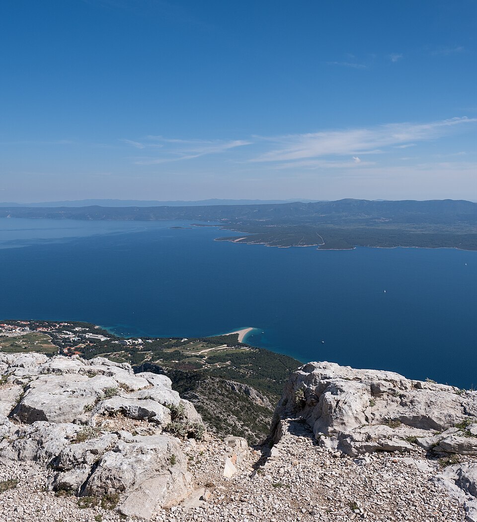
780 metres above the sea, straight above Bol. This is where you see Zlatni Rat from above – plus Hvar, Vis and, on a clear day, the Biokovo mountains. There is no entrance fee.
Straight talk
What to know before you go.
- No railings. The viewpoint drops off steeply. Hold children's hands, keep your distance, don't pose on wet rock.
- Driving down in the dark. Stay for sunset and you'll drive the narrow mountain road down in darkness. Take it slow, in low gear.
- Not in flip-flops. The ground up there is loose karst stone. Trainers are fine, beach sandals are not.
- Haze beats timing. In midsummer haze even the best light looks flat. Views are sharpest after rain or bura wind.
- Nothing to buy. No vending machine, no shop. Bring water, sun protection and snacks from below.
Getting there
Different ways up, all ending at the same spot.
By car
- 01Leave Bol on the road towards Nerežišća and climb out of town.
- 02After a few kilometres you reach the signposted turn-off for “Vidova gora”. The sign is small – slow down.
- 03About 6 km of narrow paved mountain road up to just below the summit. Single-lane in places, with passing bays.
- 04The road ends at the parking area. From there it's a few minutes on foot to the cross and the viewpoint.
Any standard rental car handles the road, but it is narrow and winding. Expect oncoming cars, cyclists and the occasional goat. Campervans and large vans: better not.
On foot
- 01Start at the upper edge of Bol, above the Dominican monastery, where the marked trail begins.
- 02The path climbs steadily through pine forest and over stone slabs. Red-and-white marks on rocks and trees.
- 03The last third is open and stony: no shade, but the view over Zlatni Rat grows with every step.
- 04At the top the trail meets the road and the parking area. Descent takes about 1.5 h – or take a taxi back.
There is no water and no kiosk along the way. Bring at least 1.5 litres per person, wear proper shoes, and don't start in the midday heat.
Other
Taxi from Bol
Taxis and minibuses drive the road up. Agree the price beforehand and arrange the return trip – there is rarely one waiting at the top.
Rental car, scooter, quad
Available in Bol and Supetar. The smallest car is plenty for the narrow road; scooters only with riding experience.
Getting to the island
Car ferry Split – Supetar, plus a summer catamaran Split – Bol. Supetar to Bol across the island takes about 40 minutes.
Loading map …
- Destination
- Parking
Check before you go
The mountain road is not a main road: during acute wildfire risk in high summer, or in strong bura wind or ice in winter, access can be closed or impassable on short notice. There is no official live status for this road – if in doubt ask your accommodation or the Bol tourist office.
Parking & arriving
On site
From the car park a short stony path leads to the summit cross and the edge above the gorge.
- Time there
- ~30–45 min, longer with a stop at the konoba
- Walk from car park
- a few minutes on a stony natural path
- Toilets
- only at the konoba, when open
- Food & drink
- seasonal konoba at the summit; opening not guaranteed
- Shade
- scattered pines, none at the viewpoint edge
When is it worth it?
Tap a time of day to see what waits for you up there.
Golden hours
18:00The recommendation. One to two hours before sunset the light turns warm and sidelong, the sand spit gains depth, the sea goes turquoise.
00–06Before sunrise
Dark, silent, often windy and much cooler than at sea level. Only for early risers with a jacket and a head torch – the car park is empty.
06–09Early morning
The clearest air of the day. Zlatni Rat sits in soft raking light, Hvar and Vis are sharp on the horizon. Almost nobody around.
09–12Late morning
Good visibility, light getting harder, temperature climbing fast. A fair compromise if the day has other plans.
12–16Midday heat
The weakest window: steep sun, flat image, hazy horizon and no shade up there. Not a time to hike.
16–19Golden hours★ Recommended
The recommendation. One to two hours before sunset the light turns warm and sidelong, the sand spit gains depth, the sea goes turquoise.
19–21Sunset
Spectacular and busiest. Expect many cars – and the drive back down the narrow road in the dark.
21–24After sunset
Blue hour, then a very dark sky above the island. Dress warm, bring a light, drive down slowly.
Guide values for the summer half-year, looking south over Zlatni Rat.
May & June
Best all-round: clear air, green landscape, comfortable temperatures.
July & August
Hot and often hazy. Go early morning or evening, avoid midday.
Sept & Oct
Very clear views, little traffic, soft light. The insider window.
Nov – April
Empty and spectacularly clear, but bura wind and rare ice on the road.
Forecast
Facts
- Elevation
- Source: DZS · 09/2026
- 780 m – highest point on Brač and the highest island peak in the Adriatic
- Opening hours
- Source: Visitors · 09/2026
- None. Openly accessible, day and night.
- View
- Source: TZ Bol · 09/2026
- Zlatni Rat, Bol, Hvar, Vis and Biokovo in clear air
- Up there you get
- Source: Visitors · 09/2026
- Summit cross, viewpoint rocks, seasonal konoba, gravel parking
- You don't get
- Source: Visitors · 09/2026
- Drinking water, railings, shade, shops, ticket desks
- Accessibility
- Source: Visitors · 09/2026
- Car to the parking area; the final stretch is stony and uneven
- Mobile signal
- Source: Visitors · 09/2026
- Usually good – still, download your map beforehand