GC-550 between Agüimes and Temisas · Agüimes, Gran Canaria
Barranco de Las Vacas
Everything you need to know before you go: Getting there, parking, prices, best time.
Last checked: September 2026
Common questions, answered
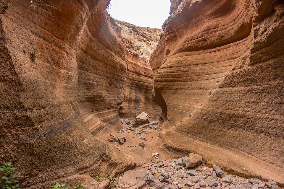
A narrow gorge where water has carved layers of volcanic ash into curved, banded walls of red, orange and cream. It sits right beside the GC-550, a couple of minutes' walk from the road.
Straight talk
What to know before you go.
- Smaller than the photos. Wide-angle shots make it look like a long canyon. In reality it's a short stop, not a hike, and works best combined with Guayadeque or Agüimes.
- Parking is the real problem. Two bays for four cars serve thousands of visitors. Firefighters, the Cabildo and people in Temisas have complained about cars in the bends since 2023. If both bays are full, drive on and come back later.
- People fall here. The press counted at least seven accidents with eight injured between 2020 and early 2024, and firefighters carried out another rescue in January 2026.
- Nothing explains it. There is no information board and no bin. Take your rubbish back with you.
Getting there
The gorge lies on the old GC-550 between Agüimes and Temisas, around km 14, where the road crosses the Barranco de Barafonso on a small bridge. There is no signpost.
By car
- 01Leave the GC-1 at the Agüimes exit and drive into Agüimes.
- 02In Agüimes take the GC-550 towards Temisas.
- 03After about 3.5 km, just before the road crosses the ravine on a small bridge, there is a bay for 2 cars.
- 04If it is taken, cross the bridge and drive about 300 m on to the second bay.
The GC-550 has no hard shoulder and no pavement, and buses and lorries use it. Leave the car only in a bay, and keep to the edge on foot.
On foot
- 01Climb over the crash barrier by the bay and scramble down into the dry stream bed.
- 02Walk through the passage under the road bridge.
- 03Follow the stream bed upstream until the walls close in and the coloured tuff begins.
The tuff is smooth and covered in sand, so it's slippery even when dry. Wear shoes with a good grip.
Public transport
No bus to the gorge
Global line 34 (San Bartolomé de Tirajana – Temisas – Agüimes) runs along the GC-550 a few times a day but has no stop here. The nearest stops, Cruce Corralillos and La Inmaculada, are 2.3 and 2.7 km away as the crow flies.
On foot
The Cabildo's S-40 trail between Temisas and Agüimes passes close by; one of its signposts stands about 350 m from the gorge. That makes it a hike, not a quick hop from the bus.
Loading map …
- Destination
- Parking
Check before you go
Storm damage can close the GC-550 at short notice: in 2026 the section west of Temisas was shut from 23 March to 17 September. Check weather warnings and road news on the day.
Parking & arriving
On site
A short slot canyon carved by water into layers of volcanic ash, with smooth, curved walls banded in red, orange and cream. The narrow part is only about 50 m long. You walk it along the dry stream bed and come back the same way.
- Time there
- ~30–45 min
- Walk from car park
- ~110 m, ~2 min from the nearest bay
- Toilets
- None
- Food & drink
- Nothing, not even drinking water. The nearest town is Agüimes
- Pushchair
- No, the way in is a scramble
- Wheelchair
- No: crash barrier, a scramble into the stream bed and loose stones
When is it worth it?
The gorge has no opening hours. What matters is how many cars are already there and whether it has rained.
Quiet times from travel reports, rain risk from the IGME geosite record.
Dry days
The usual weather in the southeast. Travel reports say there are noticeably fewer people before 10:00 and late in the afternoon.
Rain and storms
Rockfall and flash floods are possible in the ravine. Don't go in during heavy rain, with a thunderstorm nearby or while the ground is muddy.
Forecast
Facts
- Entry
- Source: IGME · 09/2026
- Free, no gate and no opening hours, public land
- Municipality
- Source: OSM · 09/2026
- Agüimes
- Rock
- Source: IGME · 09/2026
- Coloured volcanic tuffs of the Post-Roque Nublo cycle, Lower to Middle Pleistocene, exposed by water erosion
- Geosite
- Source: IGME · 09/2026
- IC3043 in the Spanish inventory of geological sites, 26 ha
- Stream
- Source: Canarias7 · 06/2018
- Barranco de Barafonso, a tributary of the Barranco de Las Vacas; the gorge lies at 513–600 m
- Road
- Source: OSM · 09/2026
- GC-550, speed limit 40 km/h
- Parking in bends
- Source: BOE (traffic law) · 09/2026
- Stopping or parking in a bend or any dangerous spot is a serious offence, fine €200
- Emergency
- Source: Gobierno de Canarias · 09/2026
- 112
Nearby
- Guayadeque ravineTrail · 2.1 km as the crow flies · Google Maps
- Casco histórico de Agüimes3.1 km as the crow flies · Google Maps
- Mirador El GurieteViewpoint · 5.8 km as the crow flies · Google Maps
- La Fortaleza de AnsiteFortress · 6.4 km as the crow flies · Google Maps
- Santa Lucía de Tirajana Park6.4 km as the crow flies · Google Maps