Barranco de Veneguera · Mogán, Gran Canaria
Los Azulejos de Veneguera
Everything you need to know before you go: Getting there, parking, prices, best time.
Last checked: September 2026
Common questions, answered
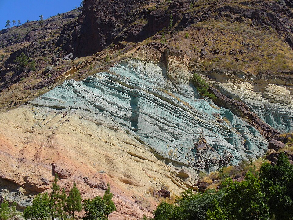
On the GC-200 between Mogán and La Aldea the hillside suddenly turns blue-green, yellow and wine-red. Hot water from the volcano altered the volcanic tuff here and changed its colour. You stop in a lay-by on the road, and two bus lines call right in front of it.
Straight talk
What to know before you go.
- A photo stop, not a day out. Without a hike you are back in the car within a quarter of an hour. No source lists toilets, so don't plan it as a rest stop.
- The slope isn't stable. After the rockfall in March 2026 the Cabildo warned of more to come. After rain, don't linger under the wall.
- If the lay-bys are full, drive on. There are only three small lay-bys, one with a bus stop. A car on the edge of the winding GC-200 is more dangerous than coming back later.
- Often called a natural monument online. The Canary Islands government's map service shows the Parque Rural del Nublo here and no separate natural monument at this spot.
Getting there
The Azulejos sit at the head of the Veneguera valley on the GC-200, the mountain road from Mogán to La Aldea de San Nicolás. You can combine them on the same drive with the Mirador de Veneguera and the turn-off to Tasartico.
By car
- 01From the south take the GC-1 to Puerto de Mogán and follow the GC-200 up through Mogán village.
- 02The road climbs to the Mirador de Veneguera, 9 minutes before the Azulejos. Worth a first stop.
- 03It then drops into the head of the Veneguera valley. The coloured wall rises on the right above the road.
- 04Stop in the first lay-by right in front of the wall, or in one of the two further up.
- 05Carrying on towards La Aldea, the GC-204 to Tasartico turns off after ~12 min. That is where the path to Playa de Güigüí starts.
The GC-200 is narrow and winding, with a 40 km/h limit at the site. Watch the traffic when you get out on the road side.
Public transport
Line 38 from Puerto de Mogán
The line to La Aldea calls at the Los Azulejos de Veneguera stop, four trips a day, two on Sundays and holidays.
Line 86 towards Playa de Tasarte
Monday to Saturday two more trips from Puerto de Mogán via the Azulejos, early morning and at midday.
Back to Mogán
On working days the last bus from La Aldea leaves in the late afternoon, on Sundays and holidays in the evening. Plan the return before you go.
From the south
Line 1 runs from Las Palmas via Playa del Inglés to Puerto de Mogán. Change there to the 38 or 86.
Loading map …
- Destination
- Parking
Check before you go
After heavy rain the Cabildo closes the GC-200 when rocks come down; in March 2026 it happened right at the Azulejos. During the Rally Islas Canarias in April the road between La Aldea and Mogán is closed for a day, in 2026 on 24 April from 7:00 to 19:00. During wildfire alerts the Cabildo can close mountain roads.
Parking & arriving
On site
A wall of tuff in yellow, blue-green and wine-red, right above the road. You see it from the car already; the lay-by gives the best view. A trail into the Inagua mountains starts at the northern lay-by.
- Time there
- ~10–20 min, several hours with a hike
- Walk from car park
- ~80 m from the first lay-by
- Food & drink
- Roadside juice stand with island fruit, according to the tourist board
- Wheelchair
- The wall can be seen from the lay-by. The trail starts steeply on loose ground.
When is it worth it?
The wall is always accessible. Tap a time of day.
Midday to afternoon
12–18The sun swings round to the south and south-west and falls straight on the wall.
00–12Morning
The sun is in the east and the wall is in shade or backlit.
12–18Midday to afternoon★ Recommended
The sun swings round to the south and south-west and falls straight on the wall.
18–21Evening
Low light from the west. The sun sets around 18:10 in December and around 19:50 at the end of September.
21–24Night
After sunset the colours are gone.
Orientation and light times are our own calculation from a terrain model and the sun's position.
Oct – May
The town of Mogán recommends these months for the trail that starts at the Azulejos.
Jun – Sep
Just as good for a roadside stop. At midday the sun is almost overhead, and it sets around 21:00.
Forecast
Facts
- Entry
- Source: OSM · 09/2026
- Free, open at all times
- Location
- Source: OSM · 09/2026
- GC-200 between Mogán and La Aldea, municipality of Mogán
- Rock
- Source: IDECanarias · 09/2026
- Rhyolitic tuffs altered by hot water on the western rim of the Tejeda caldera
- Layer thickness
- Source: IDECanarias · 09/2026
- Over 100 m at the head of the Veneguera valley
- Protected area
- Source: Gob. de Canarias · 09/2026
- Parque Rural del Nublo (C-11)
- Bus stop
- Source: Global · 09/2026
- Los Azulejos de Veneguera, lines 38 and 86
- From Puerto de Mogán
- Source: Global · 09/2026
- 38: Mon–Sat 07:00, 11:40, 16:00, 19:40; Sun/hol 07:40, 18:40. 86: Mon–Sat 05:35, 13:00; Sun/hol 13:30
- Towards Mogán
- Source: Global · 09/2026
- 38 from La Aldea: Mon–Fri 05:45, 08:00, 09:30, 14:05, 17:30; Sat without 08:00; Sun/hol 09:00, 19:55. 86 from Playa de Tasarte: Mon–Fri 14:05; Sat 06:45, 14:05; Sun/hol 14:35
- Trail R2
- Source: Turismo Mogán · 09/2026
- Los Azulejos – Los Quemados, 6.68 km, ~3.5 h, moderate to hard
Nearby
- Mirador de VenegueraViewpoint · 2.8 km as the crow flies · Google Maps
- Mirador El MulatoViewpoint · 3.2 km as the crow flies · Google Maps
- The Windmill5.1 km as the crow flies · Google Maps
- Presa de Las NiñasLake · 5.3 km as the crow flies · Google Maps
- Cactualdea ParkGarden · 6.8 km as the crow flies · Google Maps