Bandama · Las Palmas de Gran Canaria, Gran Canaria
Mirador Pico de Bandama
Everything you need to know before you go: Getting there, parking, prices, best time.
Last checked: September 2026
Common questions, answered
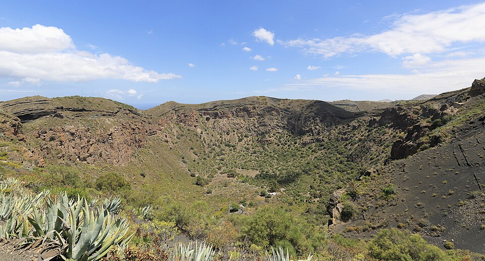
Pico de Bandama is a volcanic cone right next to the Caldera de Bandama, a crater 216 m deep and about 1,100 m across. From the top you look down into the crater and out over Las Palmas to the sea. The road goes all the way up; the bus stops about 1 km below.
Straight talk
What to know before you go.
- The summit house is shut. The information office, which used to let you see the bunker, has been closed since 2020. In 2024 the municipality described the summit as having no services and no supervision.
- The crater means a second climb. From the viewpoint you only look in. To go down you first walk the road back to Bandama, and from the crater floor it is about 230 m of ascent back to the rim. If that's your plan, take the bus straight to Bandama.
- Lots of visitors, one parking strip. The Cabildo counts about 400,000 visitors a year, most of them by car. Up top there is a single parking strip for all of them, so expect to hunt for a space.
Getting there
The summit sits between Tafira and Santa Brígida, about 16 km by road from the San Telmo bus station in Las Palmas. The GC-802 runs through the vineyards to Bandama, and from there the GC-822 winds up to the top.
By car
- 01Head towards Tafira and Santa Brígida as far as the Monte Lentiscal roundabout.
- 02Take the GC-802 exit (Carretera de Bandama) through the vineyards to the hamlet of Bandama.
- 03In Bandama turn onto the GC-822, which winds up to the summit.
- 04At the top the road becomes a one-way loop. The parking strip is right by the viewpoint.
Since 16 April 2024 vehicles over 3.5 t may not drive up to the summit. That covers coaches and heavy motorhomes.
On foot
- 01Take Global line 311 to the Bandama stop in the hamlet.
- 02Follow the GC-822 uphill to the summit.
On Saturdays, Sundays and holidays line 311 runs only every 2 hours. Check the timetable for your return before you go.
Public transport
Global line 311
Runs from the San Telmo bus station in Las Palmas via Tafira to Santa Brígida and stops at the Bandama stop.
Loading map …
- Destination
- Parking
Check before you go
The Cabildo can close the paths in the crater to protect the area or when there is a wildfire risk. It has also been planning since 2020 to keep private cars off the summit and run a shuttle from car parks nearby instead.
Parking & arriving
On site
From the summit you look south into the crater, with old fields on its floor, and north over Las Palmas to the sea. The white house on top, built in 1942, was camouflage for a military bunker. The path into the crater does not start here but about 1 km further down, in the hamlet of Bandama.
- Time there
- ~20 min at the top; ~2–3 h with the walk into the crater
- Walk from car park
- ~20 m from the parking strip
- Toilets
- On the summit, free, open again since 2024
- Food & drink
- Nothing on the summit; restaurants in the hamlet of Bandama by the bus stop
- Wheelchair
- No official information; the toilet is not wheelchair accessible according to OpenStreetMap
When is it worth it?
The viewpoint has no opening hours. What decides your visit is the visibility and, if you want to go into the crater, the ground.
Rules as of September 2026.
Clear days
The view then reaches across Las Palmas and the whole northeast of the island.
After rain
The volcanic grit (picón) on the path into the crater turns slippery, and some stretches are steeper than 18 %.
Forecast
Facts
- Entry
- Source: Ayto. Las Palmas · 09/2026
- Free, including the path into the crater
- Municipality
- Source: OSM · 09/2026
- Summit: Las Palmas de Gran Canaria
- Protected area
- Source: BOC 2005 · 09/2026
- Monumento Natural de Bandama (C-14), 325.7 ha, within the Tafira Protected Landscape
- Crater paths
- Source: Turismo GC · 09/2026
- Descent to the crater floor ~20 min, loop along the rim 3.4 km
- Bus 311 from San Telmo
- Source: Global · 03/2026
- Mon–Fri hourly 05:55–20:55; Sat, Sun, holidays every 2 h 05:55–19:55
- Bus 311 from Santa Brígida
- Source: Global · 03/2026
- Mon–Fri hourly 06:40–21:40; Sat, Sun, holidays every 2 h 06:40–20:40
- Groups
- Source: BOC 2005 · 09/2026
- Up to 10 people need no notice. Guided groups notify the Cabildo 48 h ahead
- Not allowed
- Source: BOC 2005 · 09/2026
- Camping, fires, collecting rocks or plants, take-off, landing and flying below ~300 m
Nearby
- Jardín Botánico Viera y ClavijoGarden · 3.0 km as the crow flies · Google Maps
- Piscinas de La LajaPool · 4.9 km as the crow flies · Google Maps
- Parque de las Mil Palmeras5.1 km as the crow flies · Google Maps
- Plaza San Gregorio6.1 km as the crow flies · Google Maps
- Castillo de San CristobalFortress · 6.5 km as the crow flies · Google Maps