San Agustín · San Bartolomé de Tirajana, Gran Canaria
Playa de las Burras
Everything you need to know before you go: Getting there, parking, prices, best time.
Last checked: September 2026
Common questions, answered
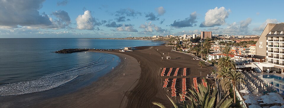
A curved bay of fine, dark golden sand between San Agustín and Playa del Inglés, closed off by a stone breakwater. Loungers, a palm-lined promenade and low apartment blocks behind. A family beach that stays calmer than its big neighbours.
Straight talk
What to know before you go.
- Dark sand runs hot. The sand is darker than at Maspalomas and heats up in the afternoon. Visitors say the fine grains get everywhere.
- Thin lifeguard cover. In May 2026 the town had 18 lifeguards for 26 beaches. A storm in February 2026 tore the roof off the Las Burras lookout, and the lifeguards watched from a car or the steps.
- Rules on paper. Ball games are only allowed in marked zones, yet in summer 2025 visitors described them all over the beach, along with cigarette butts in the sand.
- Quieter than next door. Travel guides describe families and regulars rather than the crowds of Playa del Inglés. Turespaña still rates occupancy as high, so don't expect an empty beach.
Getting there
Las Burras is in San Agustín on the south coast of Gran Canaria, between Playa de San Agustín and Playa del Inglés, just below the GC-500.
By car
- 01Take the GC-1 south and leave at the exit for the GC-500 towards Playa del Inglés and San Fernando.
- 02Follow the GC-500 into San Agustín and turn right at the roundabout into Calle Los Cardones.
- 03Continue along Calle Las Dalias into Calle Las Tabaibas. The car park is next to the Dunas Don Gregory hotel.
- 04Cross the road and walk about 250 m down to the promenade and the sand.
Parts of Calle Las Tabaibas are one-way, so the sat nav may send you round the block.
On foot
- 01At the north-east end of Playa del Inglés, join the Paseo Costa Canaria heading north-east.
- 02The promenade passes El Veril and crosses the ravines on wooden footbridges.
- 03It reaches Las Burras at the breakwater, where the fishing boats lie.
The town plans to demolish the footbridges over the GC-500 by Las Burras and to renovate the promenade. Expect diversions while work is going on.
Public transport
From Las Palmas
Line 30 runs direct from Estación Santa Catalina via San Telmo, up to three times an hour on weekdays and about twice an hour at weekends. Line 1 also stops here, every 20 minutes on weekdays and every 30 at weekends.
From the airport
Line 66 runs every hour from 07:30 to 20:30. Line 1 also passes the airport.
The stops
Shopping Centre San Agustín on the GC-500, 370–440 m from the beach. The El Veril stops on Avenida de la Unión Europea are about as far, at the west end.
Loading map …
- Destination
- Parking
Check before you go
The town can ban swimming at short notice when the water is polluted, as it did at Las Burras and San Agustín in November 2025. In heavy seas the Canary Islands government issues coastal alerts. AEMET's beach forecast for neighbouring San Agustín shows swell and water temperature.
Parking & arriving
On site
A curved bay of fine, dark sand with a stone breakwater at the south-west end, where fishing boats and pedal boats lie. The water is usually calm and gets deep gradually over sand. At low tide the beach becomes much wider. Most people stay for a few hours on a lounger.
- Time there
- ~2 h to half a day
- Walk from car park
- ~250 m from the car park on Calle Las Tabaibas
- Toilets
- At the San Agustín shopping centre, ~370 m, free
- Food & drink
- Restaurants and bars on the promenade and in the San Agustín shopping centre
- Shade
- Hired parasols only
- Wheelchair
- Adapted access and a bathing assistance service for people with reduced mobility
- Dogs
- Not allowed, except assistance dogs
When is it worth it?
The beach is open all day. Tap a time of day.
Late morning
10–13Lifeguards are on duty. In high season the nearby streets fill up before noon.
00–10Before 10:00
The sun rises over the sea and the streets still have spaces. No lifeguards yet.
10–13Late morning★ Recommended
Lifeguards are on duty. In high season the nearby streets fill up before noon.
13–17Afternoon
The dark sand gets hot. In July and August the beach is at its fullest.
17–19Early evening
From 15 June to 15 September lifeguards stay until 19:00.
19–24Evening
The bay faces south-east, so the sun sets inland behind the hotels.
Parking, crowds and the heat of the sand from visitor reports and travel guides. The sun direction is from the map.
Jun – Sep
Longer lifeguard hours. July and August are the busiest months.
Oct – Nov
Travel guides call autumn the best mix of warm weather and space on the sand.
Forecast
Facts
- Size
- Source: Turespaña · 09/2026
- About 300 m long, up to 110 m wide, fine dark sand
- Loungers
- Source: Town (press) · 09/2026
- Lounger €4.50, parasol €4.50 a day
- Water quality
- Source: Ministerio Sanidad · 09/2026
- Excellent (2025 season)
- Blue Flag
- Source: Bandera Azul · 09/2026
- Yes, for the first time in 2026
- Lifeguards
- Source: Town of S. Bartolomé · 09/2026
- 10:00–17:00, from 15 June to 15 September until 19:00
- Bus
- Source: Global · 09/2026
- Lines 1, 4, 5, 25, 30, 36, 41, 45, 52, 66, 73, 90
- Red flag
- Source: Beach bylaw · 09/2026
- Swimming banned. Fine €751–1,500
- Ball games
- Source: Beach bylaw · 09/2026
- Only in marked zones
- Saving a spot
- Source: Beach bylaw · 09/2026
- Unattended parasols and chairs may be removed
- Emergency
- Source: Gobierno Canarias · 09/2026
- 112
Nearby
- Playa de San AgustínBeach · 1.1 km as the crow flies · Google Maps
- Paseo Marítimo2.2 km as the crow flies · Google Maps
- Mirador Dunas de MaspalomasViewpoint · 2.8 km as the crow flies · Google Maps
- Mirador de las DunasViewpoint · 3.4 km as the crow flies · Google Maps
- Parque Botánico de MaspalomasGarden · 3.5 km as the crow flies · Google Maps