North end of Costa Adeje · Adeje, Tenerife
La Caleta de Adeje
Everything you need to know before you go: Getting there, parking, prices, best time.
Last checked: September 2026
Common questions, answered
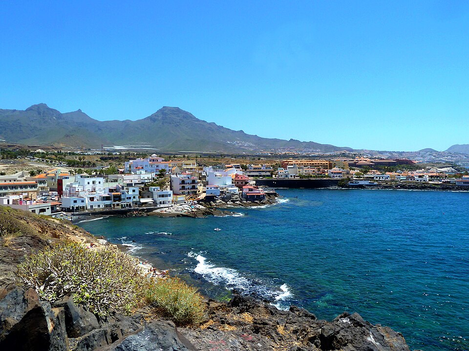
A small white fishing village at the north end of Costa Adeje, with a row of fish restaurants along a rocky bay. You come here to eat and to walk, not for a day on the sand: the swimming spots are rock and pebbles, with no lifeguards. A coastal path leads north to Diego Hernández beach.
Straight talk
What to know before you go.
- Not a sand beach. The town describes a small, narrow strip of rock. For a day on a lounger, Playa del Duque is 1.5 km away.
- No lifeguards. No lifeguards, no public toilets or showers, and guides say the waves are stronger than at Fañabé. Not ideal for children.
- Not cheap. Visitors call the fish restaurants pricey. Book for sunset.
- A protected area under pressure. Camping, rubbish and wild paths led to fines and closed paths in 2025 and 2026. Stay on the marked path.
- Diego Hernández at low tide. At high tide there is little sand left, and the path is stony.
- A building site nearby. Towards El Puertito, work continues on the disputed Cuna del Alma resort.
Getting there
La Caleta is at the end of the TF-6231, past the Bahía del Duque, on the south-west coast.
By car
- 01Leave the TF-1 at the Costa Adeje – La Caleta – Fañabé exit.
- 02Follow the TF-6231 towards Bahía del Duque to its end in La Caleta.
- 03Park in one of the car parks at the village entrance on Avenida de los Acantilados.
- 04Walk about 170 m down to Calle El Muelle and the harbour bay.
The old village has narrow streets. Park at the entrance instead of driving into the centre.
Other
Bus 467
About 25 minutes from Los Cristianos, frequent in the daytime and running until after 3:00, which suits a late dinner. From the stop it is about 250 m down to the bay.
Line 452
Also serves the village, roughly hourly on weekdays and Saturdays. On Sundays it runs only once, late in the evening.
From the airport or Santa Cruz
Long-distance buses end at Costa Adeje bus station. From there the 467 takes about 15 minutes.
Loading map …
- Destination
- Parking
Parking & arriving
On site
A short stroll along the harbour bay, past fish restaurants and boats pulled up on the pebbles, with swimming off the rocks. Many combine dinner at sunset with a walk on the coastal path north into the protected area.
- Time there
- ~1–2 h, longer with dinner or the coastal path
- Walk from car park
- ~170 m from the car park at the village entrance
- Toilets
- No public toilets or showers listed by the town
- Food & drink
- More than a dozen restaurants, mostly fish. Michelin-starred cooking in the Royal Hideaway Corales hotel
- Wheelchair
- The promenade is easy to walk; the swimming spots are rock and pebbles
When is it worth it?
The village is open all the time. Tap a time of day.
Sunset
20:00The bay faces west. In mid-September the sun sets around 20:10; in spring and autumn probably behind La Gomera.
00–12Morning
A quiet village. A good time for the coastal path to Diego Hernández, before the heat.
12–18Afternoon
Swimming off the rocks. No lifeguards, and wear shoes because of sea urchins.
18–21Sunset★ Recommended
The bay faces west. In mid-September the sun sets around 20:10; in spring and autumn probably behind La Gomera.
21–24Night
The restaurants are busy in the evening. Bus 467 runs back until after 3:00.
Sunset times are our own calculation. There are no lifeguards at any time.
Spring and autumn
The sun probably sets behind La Gomera, by our calculation.
Summer
Sunset around 21:05, over the open sea.
Winter
Sunset around 18:15.
Late July
Village fiestas with a boat procession for the Virgen del Carmen. Guides list 22 July to 3 August for 2026.
Forecast
Facts
- What it is
- Source: Town · 09/2026
- A former fishing village with a harbour bay
- Swimming
- Source: Town · 09/2026
- A small strip of rock and pebbles in the bay. No lifeguards
- Coastal path
- Source: Guides · 09/2026
- About 1 km north to Playa Diego Hernández, through the La Caleta protected area (78 ha)
- Diego Hernández
- Source: Town · 09/2026
- About 200 m of sand, no services, nudism is common
- Parking
- Source: OSM · 09/2026
- Car parks at the village entrance, free according to OpenStreetMap
- Bus
- Source: TITSA · 09/2026
- Line 467, about every 20 minutes
- Protected area
- Source: Town · 09/2026
- Stay on the paths. No camping or overnight stays
- Emergency
- Source: Gobierno de Canarias · 09/2026
- 112
Nearby
- Playa nudista de Diego HernándezBeach · 1.0 km as the crow flies · Google Maps
- Playa del DuqueBeach · 1.5 km as the crow flies
- Cala de las TortugasBeach · 1.8 km as the crow flies · Google Maps
- Playa Del Puertito De AdejeBeach · 1.8 km as the crow flies · Google Maps
- Fañabé BeachBeach · 2.6 km as the crow flies · Google Maps