Teno massif · Buenavista del Norte, Tenerife
Mirador Altos de Baracán
Everything you need to know before you go: Getting there, parking, prices, best time.
Last checked: September 2026
Common questions, answered
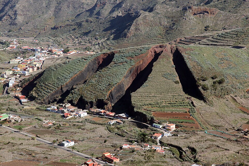
Baracán sits where the TF-436 tops out between Las Portelas and Masca. On one side the Los Carrizales ravine runs down towards the sea, on the other the green valley of El Palmar. You can stand in sunshine and watch drizzle a stone's throw away.
Straight talk
What to know before you go.
- The bus doesn't stop here. The tourism board lists a bus stop, but TITSA's stop list for line 355 has none at Baracán. Walking up from El Carrizal means 1.3 km on the road.
- One car park, nothing else. If the small car park is full, there's no other place to stop nearby. Don't leave the car on the verge.
- The view can vanish. The pass sits on the weather divide. Clouds from the north can cover El Palmar while the south side stays sunny.
- Fire alerts shut you out. Baracán lies inside the zone that closes to tourist cars on fire-alert days. There is no bus stop to fall back on.
Getting there
Baracán is on the TF-436, the only road through the Teno mountains. You can come from the north via Buenavista del Norte or from the south via Santiago del Teide and Masca.
By car
- 01From the north coast follow the TF-42 to Buenavista del Norte and turn onto the TF-436 towards El Palmar and Masca.
- 02The road climbs through El Palmar and Las Portelas to the pass. The car park is at km 12, right at the top.
- 03From the south drive up to Santiago del Teide, take the TF-436 past Cherfe and down through Masca, then climb again to Baracán.
The TF-436 is about 4 m wide with no shoulder. Near the viewpoint there are passing places; use them and let buses through.
Other
Bus 355 to El Carrizal
The nearest stop. From there it is 1.3 km uphill along the TF-436, which has no pavement or shoulder.
Which buses go that far
About ten buses a day run the full route from Buenavista and from Santiago del Teide. The extra Wednesday to Saturday buses from Santiago turn round in Masca.
On foot on the PR-TF 51
The trail crosses the road at the car park, coming from San José de los Llanos and going on to Teno Alto. Only as part of a planned hike.
Loading map …
- Destination
- Parking
Check before you go
During a wildfire alert the Cabildo can close the TF-436 through the Teno mountains to tourist and rental cars; residents and public buses still get through. Baracán lies inside the closed zone, so you cannot reach it from either side. This last applied from 30 July to 9 August 2026, 9:00–16:00. Tenerife ON shows whether an alert is in force today.
Parking & arriving
On site
From the pass you look north into the El Palmar valley with its cut-open volcano and south down the Los Carrizales ravine to the sea, with La Gomera on clear days. Information panels explain the landscape.
- Time there
- ~15 min, longer with a walk on the PR-TF 51
- Walk from car park
- a few steps from the car park
- Toilets
- None; the nearest are in Masca, about 5 km away
- Food & drink
- None; bars and restaurants in Masca
- Wheelchair
- Only some areas, according to the Tenerife tourism board
When is it worth it?
Baracán has no opening hours. What matters is fire alerts and the clouds.
Rules as of September 2026. Check alerts and the weather on the day you go.
1 Jul – 30 Sep
Wildfire season. Alerts can be declared at short notice, so check the Cabildo channels before you drive up.
Damp days
The Cabildo says the contrast between the cloudy north and the sunny south shows best on humid days. The El Palmar side may then be in cloud.
Hiking
The PR-TF 51 trail starts its western section here, around Pico Baracán towards Teno Alto. Check the weather before you set off.
Forecast
Facts
- Entry
- Source: Visitors · 09/2026
- Free, open at all times
- Location
- Source: Turismo de Tenerife · 09/2026
- TF-436 km 12, between Las Portelas and Masca
- View
- Source: Turismo de Tenerife · 09/2026
- Los Carrizales ravine, El Palmar valley and volcano, La Gomera on clear days
- Parking
- Source: OSM · 09/2026
- One small free car park, no official capacity
- Bus
- Source: TITSA · 09/2026
- No stop at the viewpoint. Line 355, nearest stop El Carrizal
- On site
- Source: Turismo de Tenerife · 09/2026
- Information panels
- Trail
- Source: Cabildo · 09/2026
- PR-TF 51 San José de los Llanos – Punta de Teno passes here
- Protected area
- Source: Cabildo · 09/2026
- Teno Rural Park. No recreational drones
- Road information
- Source: Cabildo · 09/2026
- +34 900 210 131