Corona Forestal · Santa Úrsula, Tenerife
Mirador de Chipeque
Everything you need to know before you go: Getting there, parking, prices, best time.
Last checked: September 2026
Common questions, answered
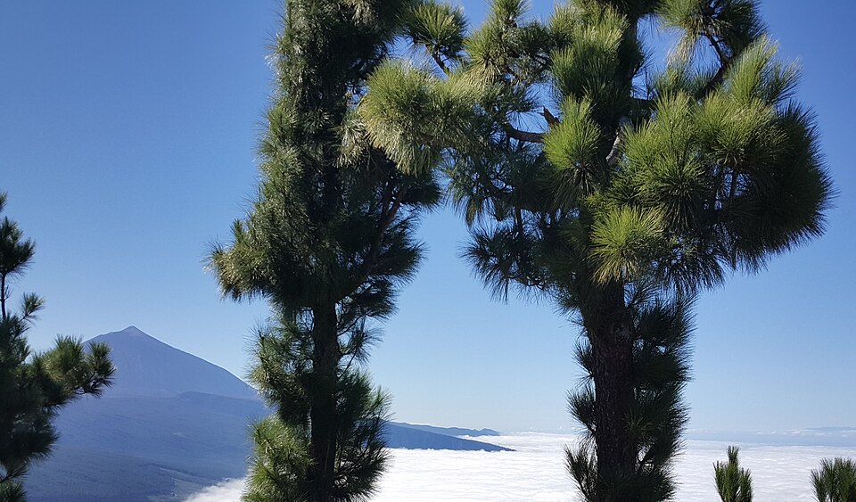
Chipeque sits on the ridge road from La Esperanza up to Teide. On a clear day you see the north coast from Punta del Hidalgo to Buenavista with Teide behind. When clouds settle over the valley, you look down on a sea of clouds instead. There is no bus, only a small car park.
Straight talk
What to know before you go.
- Sunset is chaos. The Cabildo reports crowds and jams every evening. Cars parked along the TF-24 are reported and fined.
- No bus, no toilets. You need a car or a taxi. Neither the town hall nor the tourism board lists toilets.
- The 2023 fire left its mark. Chipeque was one of the viewpoints damaged by the August 2023 wildfire. The Cabildo put out a project to replace railings, benches and panels in 2025. Completion is not confirmed.
Getting there
Chipeque is on the TF-24, the road from La Esperanza over the ridge to El Portillo and the national park. You can combine it with Teide on the same drive.
By car
- 01From La Laguna drive up to La Esperanza and take the TF-24 towards Las Cañadas del Teide.
- 02The road climbs through the pine forest. At about km 26 follow the signs for Chipeque; the Chimague viewpoint is nearby.
- 03Park in the car park at the viewpoint. The viewing terrace is right next to it.
- 04To continue to Teide, stay on the TF-24 up to El Portillo and join the TF-21.
The TF-24 above km 24 closes for ice and snow in winter and at night on maximum fire alert.
Other
Taxi
From La Laguna or La Esperanza up the TF-24. Arrange the ride back before you go up; there is no bus to fall back on.
Tour
The car park has spaces reserved for tour coaches, so tours along the TF-24 towards Teide can stop here.
Special buses only for big events
TITSA runs buses up the TF-24 only on nights like the August 2026 eclipse. Not an option for a normal visit.
Loading map …
- Destination
- Parking
Check before you go
On maximum fire alert the Cabildo can close Chipeque completely and shut the TF-24 at night; in August 2025 that meant 18:00 to 6:00. Ice and snow close the TF-24 from Los Loros (km 24) upwards, Chipeque included. The Cabildo has also announced booking and access controls for Chipeque; booking would run through Tenerife ON.
Parking & arriving
On site
The paved viewing terrace is right next to the car park. You look over the Orotava valley and the north coast to Teide, or down onto the sea of clouds when it lies over the valley.
- Time there
- ~15–30 min
- Walk from car park
- a few steps from the car park
- Toilets
- None listed by the town hall or tourism board
- Food & drink
- None; nearest restaurants at El Portillo, ~17 km up the TF-24
- Wheelchair
- Accessible, according to the tourism board
When is it worth it?
Chipeque has no opening hours. Crowds, clouds and road closures decide your visit.
Rules as of September 2026. Check the Cabildo alerts on the day you go.
Every sunset
The Cabildo reports crowds every evening, with queues and cars left anywhere along the road.
Dec – Mar
Ice and snow. In February and March 2026 the TF-24 was closed from Los Loros (km 24) upwards, which includes Chipeque.
Forecast
Facts
- Entry
- Source: Cabildo · 09/2026
- Free, open at all times outside closures
- Location
- Source: Town · 09/2026
- TF-24 about km 26, Santa Úrsula
- Official name
- Source: Town · 09/2026
- Mirador de Cumbres del Norte or Chipeque
- Protected area
- Source: Cabildo · 09/2026
- Corona Forestal Natural Park, outside Teide National Park
- View
- Source: Town · 09/2026
- Orotava valley and north coast from Punta del Hidalgo to Buenavista, Teide, La Palma on clear days
- Car park
- Source: OSM · 09/2026
- Free, coach spaces, no official capacity
- On site
- Source: Town · 09/2026
- Information panels, recycling bins
- Road information
- Source: Cabildo · 09/2026
- +34 900 210 131
Nearby
- Mirador de AyosaViewpoint · 2.0 km as the crow flies · Google Maps
- Mirador de La CrucitaViewpoint · 3.6 km as the crow flies · Google Maps
- La Caldera, Zona Recreativa La Caldera4.1 km as the crow flies · Google Maps
- Las Lagunetas5.0 km as the crow flies · Google Maps
- Mirador La TartaViewpoint · 5.1 km as the crow flies · Google Maps