Montaña Amarilla · Costa del Silencio, Tenerife
Playa Amarilla
Everything you need to know before you go: Getting there, parking, prices, best time.
Last checked: September 2026
Common questions, answered
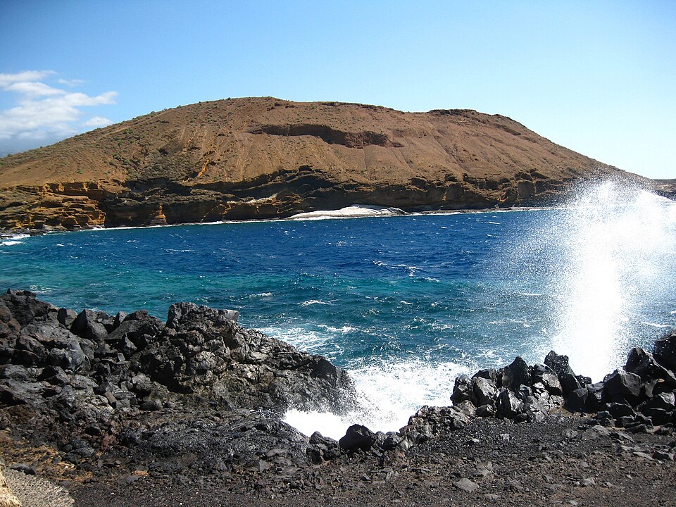
Don't expect a sandy beach. Steps lead down from the Ten-Bel side to a strip of pebbles and flat rock where people spread their towels, next to a small volcano whose yellow tuff the waves have carved into odd shapes. The water is very clear, and you get in over the rocks.
Straight talk
What to know before you go.
- It isn't a sandy beach. The tourism board lists pebbles and rock. You lie on flat rock and get into the sea over it.
- Nobody is watching. No lifeguard is documented here. If the sea looks rough, don't go in.
- No services. The tourism board lists no toilets, showers or sunbeds. OpenStreetMap shows a small bar by the steps; shops are in the resort.
- The volcano is protected. Climbing the yellow cliffs, leaving the paths and flying drones are banned in the natural monument.
Getting there
Playa Amarilla is at the southern tip of Tenerife, on the coast of Costa del Silencio next to the Ten-Bel resort and the Montaña Amarilla natural monument.
By car
- 01Take the TF-1 and turn off towards Las Galletas and Costa del Silencio.
- 02Park in the free public car park on the western side of the resort or on a residential street.
- 03Walk through the resort towards the sea and Montaña Amarilla. Concrete steps lead down to the shore.
The steps have no handrail and the rocks at the bottom are uneven. Wear shoes you can climb on.
Other
From Los Cristianos and Costa Adeje
Line 467 runs every 20 minutes during the day, at weekends too, and less often in the evening and at night. From Costa Adeje allow up to an hour.
From the stop
The Minerva stop is about 300 m from the steps, the Costa del Silencio stop with a shelter about 400 m. Walk through the resort towards the yellow mountain.
Around Las Galletas
Line 468 loops through Las Galletas, Costa del Silencio, Guargacho and Palm Mar, on weekdays only and a few times a day.
Loading map …
- Destination
- Parking
Check before you go
When the Canary Islands government declares a coastal alert or pre-alert, it advises not to swim and not to stay close to the sea, even if it looks calmer for a moment. Town halls can then close beaches and bathing areas. Current alerts are on the government's emergencies page.
Parking & arriving
On site
Concrete steps lead down from Ten-Bel to pebbles and flat rock platforms below the yellow tuff of Montaña Amarilla. You lie on the rock and get into the clear water over it; paths lead on around the volcano.
- Time there
- ~1–3 h; the loop around Montaña Amarilla adds ~1.5–2 h
- Walk from car park
- ~10 min from the public car park, then steps down to the shore
- Toilets
- None
- Food & drink
- A small bar by the steps; shops and restaurants in the resort
- Shade
- None
- Wheelchair
- Not accessible
- Dogs
- On a lead in the natural monument
When is it worth it?
The shore has no opening hours and no lighting. The sea decides whether you swim.
Check the sea forecast on the day you go.
Calm days
The tourism board praises the clear water for snorkelling and diving. On calm days getting in and out over the rocks is much easier.
Waves and high tide
At high tide waves can break over the rock platforms. The blowhole next to the steps shows how much force comes in.
On the volcano
Paths lead around and up Montaña Amarilla. Stay on them: walking off the paths and climbing are banned in the natural monument.
Forecast
Facts
- Entry
- Source: Turismo de Tenerife · 09/2026
- Free, open at all times, no lighting
- Shore
- Source: Turismo de Tenerife · 09/2026
- Pebbles and rock, about 50 × 8 m. No sand
- Services
- Source: Turismo de Tenerife · 09/2026
- No showers or sunbeds
- Lifeguard
- Source: Town · 09/2026
- None. Not on Arona's list of guarded beaches
- Protected area
- Source: Gobierno de Canarias · 09/2026
- Montaña Amarilla Natural Monument, 27.55 ha
- Monument rules
- Source: Gobierno de Canarias · 09/2026
- Stay on paths. No climbing, camping, fires, vehicles or drones
- Bus
- Source: TITSA · 09/2026
- Line 467 Costa del Silencio – Los Cristianos – Costa Adeje, every 20 min. Line 468 around Las Galletas, weekdays
- Emergency
- Source: Gobierno de Canarias · 09/2026
- 112
Nearby
- Playa San Miguel de AbonaBeach · 3.1 km as the crow flies · Google Maps
- Playa Los AbrigosBeach · 4.8 km as the crow flies · Google Maps
- Piscinas Naturales Los AbrigosPool · 5.9 km as the crow flies · Google Maps
- Mirador Montaña RojaViewpoint · 9.0 km as the crow flies · Google Maps
- Playa de Los CristianosBeach · 9.1 km as the crow flies