Cumbre · Tejeda, Gran Canaria
Cruz de Tejeda
Everything you need to know before you go: Getting there, parking, prices, best time.
Last checked: September 2026
Common questions, answered
The stone cross marks the pass in the middle of the island where the paths across the Cumbre have met since the 17th century. Today it is a stopover and a starting point: the buses stop here, and trails set off for Gáldar, Tunte and Artenara.
Straight talk
What to know before you go.
- More roadside stop than quiet lookout. The cross stands between the road, the car park, the stalls and the restaurants. If you want a lonely view, this isn't it. If you need coffee, a toilet and a trailhead, it's exactly right.
- The pass is often inside the cloud. The sea of clouds reaches up to about 1,500 m, which is roughly the height of the pass. The Cabildo warns of fog and drizzle on the trails from here. Then you see neither Nublo nor Bentayga.
- Sunset needs a car. The last 305 leaves Tejeda for San Mateo at 18:00. For an evening at the pass and the drive back afterwards you need a car or a taxi.
Getting there
Cruz de Tejeda is the pass on the GC-15 between San Mateo and Tejeda. The GC-150 branches off here, north towards Pinos de Gáldar and Artenara, south to Pico de las Nieves.
By car
- 01From Las Palmas drive to San Mateo and follow the GC-15 uphill to the pass.
- 02From the south go up through Fataga, San Bartolomé de Tirajana and Ayacata into the middle of the island, then via Cruz de Los Llanos to the pass. This is also the route of bus 18.
- 03Park in the large car park next to the Parador. The cross and the viewpoint are about 100 m away.
- 04Carry on down the GC-15 to Tejeda, or take the GC-150 to Artenara or to Pico de las Nieves.
In snow, ice or heavy rain the Cabildo closes the GC-15 and GC-150.
Public transport
Bus 305 from San Mateo
Six trips up Monday to Saturday, three on Sundays and holidays. The last bus back over the pass to San Mateo leaves Tejeda at 18:00.
From Las Palmas
Take line 303 from San Telmo to San Mateo, every 30 minutes daily, and change to the 305 there.
Bus 18 from the south
From Faro de Maspalomas three times a day via San Bartolomé and Roque Nublo to Tejeda, and three times back.
Line 18 loop
During the day the 18 runs a loop about every 30 minutes: Tejeda, Cruz de Tejeda, Cruz de Los Llanos, Roque Nublo, Ayacata. That links both places without a car.
Loading map …
- Destination
- Parking
Check before you go
In snow, ice or heavy rain the Cabildo closes the roads to the Cumbre, including the GC-15 and GC-150 at the pass. From wildfire level orange, forests and trails are closed. Rallies and roadworks can close the GC-150 or GC-15 at the pass for hours; buses are then diverted.
Parking & arriving
On site
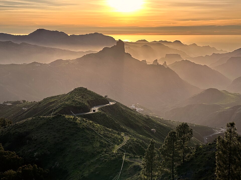
A square on the mountain road: the stone cross, the Parador behind it and stalls selling almond sweets and other local produce. From the viewpoint you look across the Tejeda caldera to Roque Nublo and Roque Bentayga.
- Time there
- ~20–45 min, longer as the start of a hike
- Walk from car park
- ~100 m from the large car park
- Toilets
- Public toilets on the square, one with an accessible toilet and baby changing
- Food & drink
- Several restaurants and bars on the square, a café and restaurant in the Parador, stalls with almond sweets
- Wheelchair
- Viewpoint accessible, according to OpenStreetMap
When is it worth it?
Cruz de Tejeda has no opening hours. Clouds and road closures decide your visit.
As of September 2026. Check closures and the wildfire alert level on the day.
Late afternoon
The view to Roque Bentayga faces west. At sunset the rock stands against the light above the caldera, as in the photo above.
Dec – Feb
Snow and heavy rain. In December 2025 snow closed the GC-15 between Las Lagunetas and Tejeda, and in January 2026 rockfalls hit the GC-15 and GC-150.
Jul – Sep
Wildfire risk. In August 2025 the Cabildo closed the trails around Tejeda.
Forecast
Facts
- Entry
- Source: OSM · 09/2026
- Free, public square
- Location
- Source: OSM · 09/2026
- Pass on the GC-15 and GC-150, municipality of Tejeda
- Bus 305 up from San Mateo
- Source: Global · 07/2026
- Mon–Fri 8:00, 10:30, 12:30, 14:05 (school holidays 14:10), 16:00, 20:00. Sat 8:00, 10:30, 12:30, 14:00, 16:00, 20:00. Sun and holidays 8:00, 10:30, 17:00
- Bus 305 back from Tejeda
- Source: Global · 07/2026
- Mon–Sat 7:00, 9:00, 11:30, 13:00, 15:05 (Sat 15:00), 18:00. Sun and holidays 9:00, 11:30, 15:00, 18:00
- Bus 18 Maspalomas
- Source: Global · 12/2025
- From Faro de Maspalomas daily 8:00, 9:00, 15:00. Back from Tejeda 10:30, 13:00, 17:30
- Bus 303 Las Palmas – San Mateo
- Source: Global · 03/2026
- From San Telmo daily 7:00–22:00 every 30 minutes
- Bus stop
- Source: OSM · 09/2026
- “Cruz de Tejeda”, ~85 m from the cross
- Trails from here
- Source: Cabildo · 09/2026
- S-01 to Gáldar 22.5 km, S-50 to Tunte 15 km, S-90.A to Artenara 7.3 km, S-85 loop via Tejeda 11 km, plus S-09, S-10, S-15 to Valleseco and Teror
- Camino de Santiago
- Source: Gáldar town hall · 09/2026
- End of the stage from Tunte, start of the stage to Gáldar
- Tourist info
- Source: Cabildo · 09/2026
- In kiosk no. 2 among the stalls
- Global
- Source: Global · 09/2026
- +34 928 25 26 30
Nearby
- Mirador Degollada de BecerraViewpoint · 2.1 km as the crow flies · Google Maps
- Mirador Astronómico de Pinos de GáldarViewpoint · 4.0 km as the crow flies · Google Maps
- Roque NubloMountain · 4.4 km as the crow flies
- Roque BentaygaMountain · 4.4 km as the crow flies · Google Maps
- Museo Etnográfico Casas Cueva de Artenara4.7 km as the crow flies · Google Maps