La Cumbre · Vega de San Mateo, Gran Canaria
Pico de las Nieves
Everything you need to know before you go: Getting there, parking, prices, best time.
Last checked: September 2026
Common questions, answered
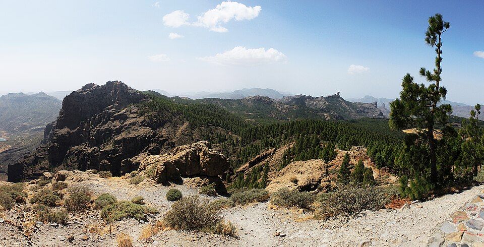
A stone semicircle right below the Air Force radar dome, almost at the top of the island. To the west lie Roque Nublo, Roque Bentayga and the Caldera de Tejeda, with Teide on Tenerife behind them on clear days. On cloudy days the sea of clouds hangs in the ravines below you.
Straight talk
What to know before you go.
- You are not standing on the very top. The summit plateau belongs to the Air Force, with the radar dome behind the wall. The viewpoint sits just below, and the true highest point is a different rock. For the view it makes no difference.
- Sunset means a traffic jam. Every evening dozens of cars try for a handful of spaces. Unlike at Roque Nublo, nobody manages access here.
- Cold, even in summer. At almost 2,000 m it is much colder than on the coast. The Cabildo recommends warm clothes and sturdy shoes, even though the walk is short.
Getting there
The viewpoint sits at the end of the GC-134, a short spur off the GC-130. Winding mountain roads lead up from every direction.
By car
- 01From Las Palmas take the GC-1 to Telde, head towards Valsequillo and climb the GC-130 into the Cumbre.
- 02From the north and west take the GC-15 to Cruz de Tejeda, then the GC-150 to the GC-130.
- 03From the south take the GC-60 to Ayacata, then the GC-600 past Llanos de la Pez to the GC-130.
- 04Turn off the GC-130 onto the GC-134. It leads to the viewpoint car park below the radar station.
The GC-134 closes completely for ice and snow, as it did in December 2025 and March 2026.
Public transport
Line 18 to Cruz de Los Llanos
Global line 18 between Faro de Maspalomas and Tejeda stops at the Cruz de Los Llanos car park. From there it is about 3.1 km on foot, around 45 minutes, partly along the road.
No bus back after sunset
The last bus passes too early to get back after sunset. To see the sunset you need a car.
Loading map …
- Destination
- Parking
Check before you go
For ice and snow the Cabildo closes the GC-134 and often other roads into the Cumbre. On wildfire alert days forests and trails are closed to visitors; if a fire breaks out nearby, access roads such as the GC-130 are closed too. Check on the day you go.
Parking & arriving
On site
A walled semicircle with an information panel, facing west over the Caldera de Tejeda: Roque Nublo, Roque Bentayga, Tamadaba to the north-west and Teide on clear days. Two restored 17th-century snow pits are close by.
- Time there
- ~20–30 min, ~1 h with the snow pits
- Walk from car park
- a few steps from the car park, steps at the end
- Toilets
- None at the viewpoint; nearest at the Llanos de la Pez picnic area, ~1.3 km
- Wheelchair
- Not accessible, steps up to the terrace
When is it worth it?
The viewpoint has no opening hours. Clouds, light and the evening crowd decide your visit.
Morning
07–13The sun is behind you and the view west to Roque Nublo and Bentayga is in full light. On cloudy days the sea of clouds fills the ravines.
00–07Night
An official stargazing viewpoint. Looking south you see constellations that never rise over mainland Europe, such as the Southern Cross. It is cold at night.
07–13Morning
The sun is behind you and the view west to Roque Nublo and Bentayga is in full light. On cloudy days the sea of clouds fills the ravines.
13–17Afternoon
The sun moves west over the Caldera de Tejeda and the view towards Teide slowly turns into backlight.
17–21Sunset
The semicircle faces due west and the sun sets over the Caldera de Tejeda. That is exactly when everyone comes: the car park fills up and the access road jams.
21–24Evening
After sunset the stars come out. Dress warmly.
Based on experience and the way the viewpoint faces, as of September 2026.
Dec – Mar
Ice and snow are possible. The GC-134 was closed in December 2025 and March 2026.
Jun – Sep
Wildfire season. On alert days forests and trails are closed. In September 2026 a fire near Cazadores closed the GC-130.
Forecast
Facts
- Height
- Source: IGN · 09/2026
- 1,949.98 m at the Pico de las Nieves survey point
- Highest point of the island
- Source: GRAFCAN · 09/2026
- Morro de la Agujereada, 1,956 m, about 150 m south
- Radar station
- Source: Ejército del Aire · 09/2026
- Air Surveillance Squadron 21 of the Spanish Air Force, restricted military area
- Snow pits
- Source: Cabildo · 09/2026
- Pozo de Los Canónigos (1669), ~250 m; Pozo Grande (1694), ~540 m. Restored, signposted and open to visit
- Bus
- Source: Nublo bus timetable · 09/2026
- Global line 18, stop Cruz de Los Llanos. Last listed departure 18:36
- Night temperature
- Source: Turismo Gran Canaria · 09/2026
- Winter average 3 °C, often near 0 °C. Summer average ~15 °C
- Sunset
- Source: Own calculation · 09/2026
- ~18:10 in December to ~21:00 in June
- Road information
- Source: Cabildo · 09/2026
- X @carreterasCabGC, emergencies 112
Nearby
- Llanos de La Pez1.3 km as the crow flies · Google Maps
- Ventana del Nublo2.7 km as the crow flies · Google Maps
- Caldera Los Marteles ViewpointViewpoint · 3.6 km as the crow flies · Google Maps
- Mirador Degollada de BecerraViewpoint · 3.6 km as the crow flies · Google Maps
- Roque NubloMountain · 3.9 km as the crow flies